Unmanned Aerial Vehicle (UAV) Technology in a Forestry Management Environment
In 2014, Danzer Forestland, the North American Hardwoods management arm of Danzer, began exploring the possibility of incorporating the use of UAV technology into a forestry management environment.
More commonly referred to as “drones”, this technology has been quick to find a market in a multitude of industry sectors, and for as many reasons. The potential benefits (efficiencies, accuracy of data collected, speed, safety, etc.) are certainly compelling. However, as is often the case, there is more than meets the eye.
UAV technology is not new. In fact, according to Wikipedia: “The earliest recorded use of an unmanned aerial vehicle for warfighting occurred on August 22, 1849, when the Austrians attacked the Italian city of Venice with unmanned balloons loaded with explosives known as 'Austrian balloons'.”
Of course, today’s UAVs are a far cry from those described as being in use in 1849. The widespread adoption of this technology has opened new possibilities in the fields of surveying, agriculture, structural integrity assessment (wind turbines, bridges, towers, etc.) and more.
The more accurate terminology is Unmanned Vehicle Systems (UVS) which covers applications beyond the air space. These high-tech, highly maneuverable, remote controlled devices can be deployed on land, sea and air and can carry an array of electronic sensors capable of collecting vast amounts of data, typically in a fraction of the time it takes using more traditional methods.
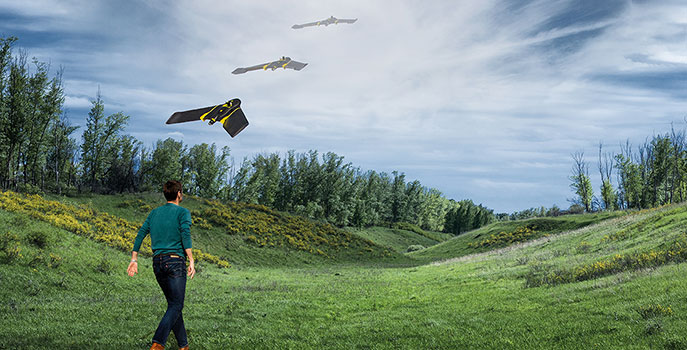
One of the most appealing aspects of UAV technology is its ability to fly a mission sight unseen. Simply program the mission using a laptop computer, upload it to the craft using a USB thumb drive and toss it into the air. It will fly the mission on its own and return to its launch coordinates without any further input from the operator.
What does this mean for Danzer?
The big question for Danzer is, how might incorporating the use of UAV technology into our forestry management operations produce tangible benefits? Clearly the forest industry is a sizable global market so it seems only logical for Danzer to consider the potential solutions this technology could bring to our forest management operations.
One example is how much time it currently takes to assess the health and quality of a timber resource on a larger property. Standard practice is to have one or more foresters walk the land and assess the timber from the ground prior to acquisition, or as part of an ongoing effort to manage the resource over the long term. Incorporating UAV technology could provide a more efficient means of gathering images and data from a different perspective and, the craft can typically cover a much larger area in far less time than it takes a forester to physically walk a particular tract of land.
Additionally, UAVs might be used for mapping surface infrastructure such as logging roads, skid trails, landings and utilities or even delineation of recently harvested timber stands. Ideally, with the use of a LiDAR (Light Detection and Ranging) we might one day deploy UAVs to measure and calculate timber volumes. The possibility of identifying timber species, delineating timber stands and assessing forest health from the air would be an added bonus.
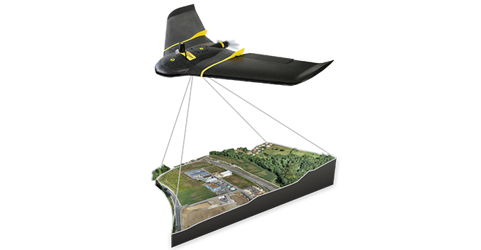
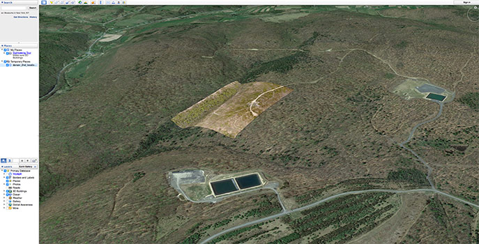
In 2016, Danzer hosted a “proof of concept” demonstration conducted by a prominent UAV manufacturer on a large tract of timberland located in north central Pennsylvania. During this demonstration, a winged micro UAV flew a mission over roughly 500 acres and collected high resolution imagery which was later converted into a georeferenced 3-dimensional point cloud. While the resolution of the final images was indeed impressive, as was the time to capture the imagery (less than 2 hours total flight time), the massive amount of digital data collected for just this one mission took nearly 24 hours to process! That’s just one example of the many challenges industries such as ours will face as they continue to explore this promising technology. The UAV craft itself is nearly ubiquitous. Whether it’s a winged or rotary craft, there is a veritable smorgasbord of options. At the end of the day, it’s data acquisition, processing, cost/benefit analysis, customizing solutions and management that pose the biggest hurdles.
A lot of open questions
Many questions remain which for now has us taking somewhat of a measured approach. What is the overall cost to integrate this technology? Do we bring it “in-house” or contract these services out to a third party? Will the Federal Aviation Administration (FAA) pass sensible regulations that will permit UAV craft to occupy a shared air space? Will the available sensor technology provide Danzer with tangible results? How do we develop customized solutions specific to our industry?
These questions and more will need to be answered before we have enough confidence in the technology to move forward with such a program. In the meantime, we will continue to keep our finger on the pulse of the UAV industry with hopes that someday, the presumed benefits will become a reality.
Photos courtesy of senSefly, a Parrot company
To subscribe to this blog copy the following URL to your feed reader: http://www.danzer.com/en/company/media-relations/danzer-blog/feed/rss/blog?format=feed
About the Author

Senior Land Manager Danzer Forestland
A Registered Professional Landman, Dave Perazone is responsible for managing Danzer’s North American oil, gas and mineral interests. His role has expanded to include research into the use of unmanned vehicle systems in a forest environment, subdivision of larger parcels of land in preparation for sale and managing GIS mapping for all of Danzer’s North American properties. Dave and his wife Kim live in upstate NY spending as much time as possible with their four grandchildren. When he isn't fishing, Dave enjoys playing the drums and building furniture in his wood shop.